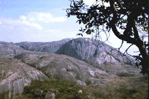
The Matobo Hills, some 24.9 miles south of Bulawayo, are remarkable for their unusual scenery and the diversity of their flora and fauna. They are also a focal point of much of Zimbabwe's history and prehistory. The hills cover about 790 700 acres and have been eroded from an exposed granite batholith thought to be over 3 000 million years old.
Hump-backed domes ('dwalas') have resulted from exfoliation of the granite; crenellated ridges, often surmounted by remarkable 'balancing rock' formations, have been formed by erosion along regular fault lines in the rock. In most of the area the hills are aligned into steep ridges, often densely wooded on their lower slopes, and separated by valleys containing numerous streams, springs, seeps and vleis.
They support a flora ranging from lichens, figs and aloes to Brachystegia species, mopane trees and over 100 grass species. Human habitation in the Matobo Hills stretches back at least 40 000 years. The evidence for this long period of habitation comes from the deep layers of human detritus excavated from the many caves and rock shelters in the hills.
The Matobo region is particularly well known for the number and quality of its Stone Age rock art sites. Among the most important are Nswatugi Cave, Bambata Cave, Silozwane and Pomongwe.
The hills were the scene of the famous indaba between Cecil Rhodes and Ndebele leaders in 1896. Rhodes and several other leading early white settlers are buried on the summit of Malindidzimu, the 'hill of the spirits', 27.4 miles south of Bulawayo.
Some 105 000 acres of the region is now included in the Matopos National Park, which dates back to 1904 when a game enclosure was established on the northern edge of Matobo Hills and stocked with sable antelope, waterbuck, reedbuck, zebra, eland, giraffe and a camel.
Today's national park includes the Maleme, Mpophoma and Togwana Dams, many of the more spectacular hills such as Malindidzimu, Inungu and Pomongwe, and most of the region's finest examples of rock art. A northerly extension, lying along the Maleme-Bulawayo road, forms the Matopos Recreational Park.
Except for indigenous species such as bushbuck, klipspringer and leopard, most of the mammal population has been reintroduced in recent decades. The biggest concentrations are to be found in the Whovi wildlife section west of the Bulawayo-Kezi road.
A buffalo herd of 200 was shot in the early 1980s to comply with veterinary regulations concerning the control of foot-and-mouth disease.
The unmistakable depiction of white rhinoceros in one of the cave paintings encouraged the Department of National Parks and Wild Life to reintroduce this species and more than 30 animals are now spread through the park, both inside and outside the fenced wildlife area.
Out of the 189 mammal species indigenous to Zimbabwe, 88 have been recorded in the Matobo Hills. Duiker, steenbok, reedbuck, impala, bushpig and warthog occur throughout the park, and the region also has Zimbabwe's highest density of leopards, which prey on the abundant populations of dassies, baboons and other smaller species.
About 330 bird species have been recorded, including 40 species of raptors and the highest density of black eagles recorded anywhere in Africa.
The hills were named Amatobo, meaning the 'bald-headed ones', by the Ndebele king, Mzilikazi; later this was corrupted to 'Matopo' by white settlers.
The hills are reached via a good tarred road from Bulawayo, which leads to the National Park headquarters at Maleme Dam, and are crossed by a network of viewing tracks. Accommodation is available in the form of lodges and camping and caravanning sites.
The Matopos National Park is a candidate for World Heritage status under the UNESCO World Heritage convention because of its outstanding cultural and natural importance.